There are times one needs a “Plan B” for traveling too. This does not only apply to a single trip but also for a whole period of time.
What does “Plan B” stand for? In general it is “A contingency plan … devised for an outcome other than in the usual (expected) plan” (according to Wikipedia).
Personally and more specifically I interpreted “Plan B” as locations all starting with the letter “B” to visit. Many of them were listed on my (too long) schedule of places to visit for a long time. Suddenly they moved up to the top due to general travel restrictions.
There is “Borkum” to start with.
Borkum is located in the northwest of Germany. It is an element of the Lower Saxon Wadden Sea National Park (“Nationalpark Niedersächsisches Wattenmeer”). The biggest and westernmost island of the East Frisian Islands (“Ostfriesische Inseln”) marks the mouth of the river Ems where it enters the North Sea. For long times lighthouses and beacons were built to enable a safe approach.
")
")

")


Tourism has always played a major role as an income provider for the recent about 200 years. During preseason one finds long empty sand beaches, crowded playgrounds are hardly to imagine.
Since the beginning of the last century Borkum has been an important military base. It carried the status of a “sea fortress”. The military barrack now is converted to a youth hostel.
First missile tests under the leadership of Wernher von Braun were carried out at the eastern part of Borkum until they moved to Peenemünde at the Baltic Sea. They laid the ground for the later moon landing whose fifties anniversary has taken place recently. Still today the landscape shows traces of the earlier usage if you look closely.


Completely different is the “Black Forest”.
The Black Forest is located in the southwest of Germany. The largest German “Mittelgebirge” (mountain range with hills and mountains from 200 m to 1000 m higher than the surrounding area) is the most visited tourist region among its kind.
Well known rivers have their source here – like the Danube. Lakes of natural glacial origin store water and invite to a stroll or hike – like the “Titisee” and “Feldsee”. Originally smaller ones were dammed up and function today as water reservoirs to feed turbines of hydroelectric power stations – like the “Schluchsee”.


")

As the name suggests the Black Forest invited to forestry what fed the people living here in the past – besides ore mining. The recent years the bark beetle and storms had their share in timber harvesting. Tourism has become a major source of income. The “Feldberg” with an elevation of 1493 m as the highest German mountain besides the German Alps provides a well-developed walking infrastructure – no climbing required.

 - Highest German mountain outside the Alps")


Raw materials and goods were transported by railway and required the construction of gorge crossing bridges. The current “Ravenna Bridge” (succeeding its predecessor in the 1920s) found many replicas in model railways. To meet the challenges of heavy snow it is heatable – the only heated railway bridge in Germany.
Today global warming made many ski jumps redundant in lower situated ski resorts.
Remote location, high wind loads, masses of snow and abundance of timber led to the development of a unique stile of dwelling – the “Black Forest house”. A millennium ago the isolation attracted monks to found a monastery. Centuries later obviously growing wealth allowed the construction of St. Blasien cathedral. Today the monastery complex has been converted to a college.

")
")


Also a German “Mittelgebirge” is the “Bavarian Forest”.
The Bavarian Forest is located in the southeast of Germany. Together with surrounding areas it forms the biggest coherent forest region of Bavaria; in connection with the directly attached “Bohemian Forest” it presents itself as one of the biggest in Europe.
The headwaters of many rivers are to be found in the Bavarian Forest. One of them is the “Regen” which later joins the Danube (which has its source in the Black Forest).
")


, Czech-German art project")
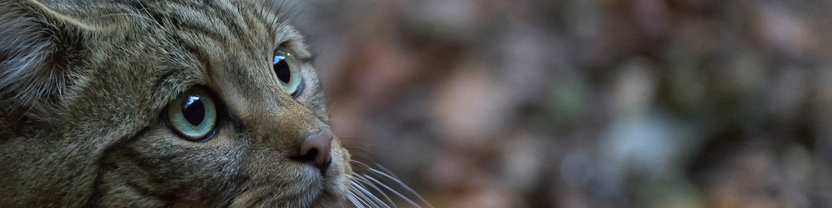
Hiking the Bavarian Forest one can encounter wild animals like Red Deers, Boars and Wildcats.
")
")
")
")
Especially in autumn the weather changes from day to day and during the course of the day. Nights starting with a few clouds over green mountains open the next morning with the first snow on the “Großer Arber”, the highest mountain of the Bavarian Forest.
The next day starts with fog – one almost can’t see the own hand in front of the eyes – transforming into a sunny day with only a few clouds in the afternoon.
Taking this chance to climb the highest mountains of the Bavarian Forest National Park (“Großer Rachel” and “Lusen”) one passes through block-falls and can’t miss the traces of the bark beetle.

")


")
 - summit cross")
 summit cross")
Looking down the “Lusen” invites to walk the border climb between Czechia and Germany. Hiking from border stone to border stone one often stands with one leg in Czechia and with the other in Germany. Vegetation doesn’t know of any borders.


\", Border to Czechia")


Being a really green border it is just a step across the red line at the railway station of Bayerisch Eisenstein (“Eisenstein” until 1951) to go from Germany to Czechia and vice versa. The rails lead to “Markt Eisenstein” in Czechia.

")
 - View from Czechia to Germany")
“Berlebeck”, belonging to Detmold, is located at the northern edge of the Teutoburg Forest.
The Teutoburg Forest is a further German “Mittelgebirge”, its majority building the two nature parks “TERRA.vita Nature Park” and “Teutoburg Forest/Egge Hills Nature Park”. Nature parks are now protected landscapes preserved in their present state and promoted for tourism purposes. Typically a nature park results from agricultural usage or forestry.


The Teutoburg Forest as many other forests suffers from bark beetle infestation and dry summers. There is no cure for the forest dieback. The woods are to cut providing room for different wood fit for future demands.


In contrast to the view of the woods passing away a visit of the Heiligenkirchen bird park (neighboring Berlebeck) is a real pleasing adventure. One meets different species of birds from parrots to storks. Don’t miss the rodents on the ground!
")
")
")
")
")
")
")
")
")
")
The eagle station Berlebeck hosts, nurses and nurtures birds of prey.
")
")
")
")
")
")
")
")
")
The Teutoburg Forest is historical ground. Berlebeck lies right in the middle between various monuments erected by men or nature.
There are castle ruins as well as the famous Hermann’s Monument, commemorating the “Battle of the Teutoburg Forest” or “Varian Disaster”. This 1875 inaugurated statue is Germany’s highest and was the highest of the western world until the completion of the “Statue of Liberty” in 1886.
The “Externsteine” is a distinctive sandstone rock formation regularly visited by many tourists.


")


Barnacle geese gather on Neuwerk on their migratory flight to the north or south depending on the time of the year.
The radar tower and the reconstructed eastern beacon on the tidal island in the mouth of the river Elbe into the North Sea seem to be navigational aids on their flights.


Also Neuwerk lighthouse seems to help birds to find their way along the dike encircled island. The navigational light was shut down in 2014 as no longer needed for shipping after almost 200 years of operation.


Large ships pass Neuwerk on the deep water way to and from Hamburg. Well marked routes through the tideland become visible at low tide allowing approach from mainland even by feet. Jetties and the small harbour fall dry at low tide. At high tide ferries may berth at the jetty for about three hours.


Berlin – Germany’s capital – receives visitors arriving by train with modern architecture. Berlin Central Station is located directly at the river Spree. The river passes the inner city. Cruising the Spree gives an impression of recent decades’ architecture and history.


Well known monuments are located around the “Platz der Republik” (republic square).

")
")


Watching out one also spots Chancellor’s Office at the “Platz der Republik” and the new German parliament building at both sides of the river Spree – “Bridge Building”.


Berlin-Tempelhof Airport was one of the first airports in Berlin and one of the first passenger airports in Germany. During cold war the Soviet Union blocked Berlin from 24 June 1948 to 12 May 1949. The Western Allies organised the Berlin Airlift to provide Berlin’s inhabitants with food and other supplies. The Airlift Memorial commemorates all who were involved in this relief action. One pilot started dropping little raisin packages during landing approach. That’s what the planes got their name from: “raisin bomber”.
")

")


The airport buildings also housed a bunker where aireal images were stored. This film archive was burnt down completely in 1945 at the end of the war. Air condition and heating was demolished too. During war the Berlin people found cover in the air-raid shelters under the building complex. The never fully completed airport ceased operations in 2008.


US Air Force closed their US Army Aviation detachment at Berlin-Tempelhof in 1994 leaving a “Gateway to Freedom”. The Tempelhofer Feld (“Tempelhof Field”) now is open to the public and used as a park. The final usage still is matter of ongoing discussions.


Directly on the doorstep Burgholz Waymarking has been an ongoing project. Almost naturally it became part of “Plan B” if not the real origin.